The Chilean Coastal IOCG Belt.
The Chilean Coastal IOCG Belt is centered on the Coastal Cordillera range of northern Chile, which is dominantly comprised of Late Jurassic and Cretaceous age volcanic, volcano-sedimentary and intrusive rocks. The north-south belt is considered to represent a linear array of interconnected Mesozoic continental margin rift basins (e.g., Chen et al., 2013; Bonson et al., 1997) or back-arc basins. The belt is typically considered to extend from latitude 31°S to 22°S and be controlled by the arc-parallel regional Atacama Fault System (Scheuber and Gonzalez, 1999).
The IOCG mineralization in the belt is broadly contemporaneous with manto-style deposits, as well as magnetite-dominated iron-rich copper-poor deposits. Key examples of the Chilean IOCG and allied deposits (and their published mineral resources) are:
- Candelaria (1207 Mt @ 0.54% Cu, 0.13 g/t gold, Measured and Indicated Mineral Resources – Lundin Mining December 31, 2023 Mineral Resource and Mineral Reserves Statement)
- Mantoverde (588 Mt @ 0.46% copper, 0.1 g/t gold flotation and 456 Mt @ 0.29% CuS leachable material, Measured and Indicated Mineral Resources– Capstone Copper Mineral Resources and Reserves Statement 2024),
- El Espino (144 Mt @ 0.55% Cu, 0.22 g/t Au, Measured and Indicated Resources, El Espino-Venus NI 43-101 Technical Report – Effective Date 20 January 2011),
- Santo Domingo (547Mt @ 0.31% Cu, Measured and Indicated Mineral Resources, Capstone Copper Mineral Resources and Reserves Statement 2024).
La Higuera IOCG Project
The La Higuera IOCG Project is located approximately 40km north of the city of La Serena in Coquimbo province within the low-lying central valley approximately 10km from the coast.
Local Geology
The La Higuera Mining District is dominated by volcanic and intrusive rocks of the Jurassic-Cretaceous arc and appears to have a lesser volcano-sedimentary component than further north in the belt. Most of the project area lies within a zone along the Atacama Fault System (“AFS”) where an inlier of Jurassic diorite (the San Juan Pluton – Jsj) dated at 148±6 Ma is in poorly constrained contact with Jurassic andesitic volcanic units (Jas). The area is enclosed by lower-middle Cretaceous felsic-dominated intrusive units (Kigd) that range in composition from monzonite to diorite, and yield ages of 115-130 Ma (Figure 1).
The relationship between iron-copper mineralization and the structural history of this portion of the AFS is interpreted and documented from the Dominga deposit by Veloso et al. (2017) and Heuser et al. (2020). The main segment of the AFS in the La Higuera Mining District is termed the El Tofo Structural System and comprises a north-northeast trending steep structure with evidence of sinistral strike-slip movement.
Known mineralization in the southern end of the Chilean IOCG Belt, particularly in the La Higuera Mining District, typically has magnetite as the more common iron oxide mineral. Literature on the mineralization styles in the Chilean IOCG Belt typically ascribe the origins of the mineralization to being magmatic-related (the large Jurassic-Cretaceous felsic-intermediate suites present in the cordillera), or a combination of this magmatic system (providing fluids and/or heat) and basinal fluids (Barton, 2009). These basinal fluids are potentially sourced from the back-arc basin volcano-sedimentary pile via expulsion/liberation during inversion of the back-arc basins during transpressional phases of the dominantly sinistral strike-slip movement on the Atacama Fault System during the Jurassic to Middle Cretaceous (190-110 Ma).
The most visible alteration in the project areas is a strong magnetite + albite + actinolite alteration assemblage that typically occurs associated with vein sets and\or as pervasive alteration. The alteration can also be accompanied by combinations of epidote, chlorite, apatite, calcite, titanite, allanite, scapolite, hematite and K-feldspar (Figure 2). The magnetite + albite + actinolite alteration is reflected in the large and high intensity magnetic anomalies evident in the ground magnetic datasets.
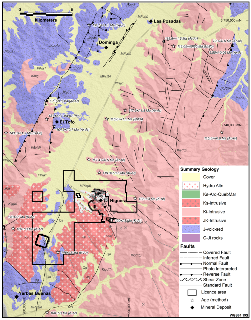
Figure 1. Regional geological map of the La Higuera Mining District. Modified and summarized from the SERNAGEOMIN 1:100000 scale geological map. The property outline is shown. (source: data and base map from SERNAGEOMIN)
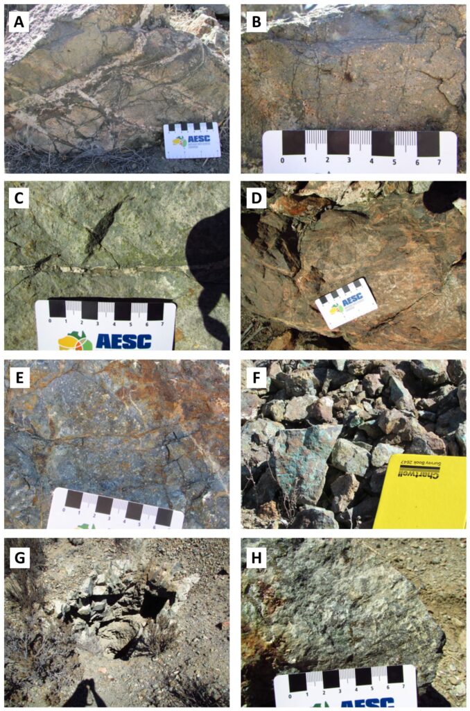
Figure 2: Field examples of common rock types from the Gaby prospect. A) Porphyritic andesite boulder with thick (2cm) magnetite-quartz veins and thinner (3mm) magnetite veins with pink albite selvedges. B) close-up of the porphyritic andesite, plagioclase phenocrysts within a green altered (actinolite?) ground mass. C) dark grey andesite with quartz veins with magnetite-epidote selvedges. Vein orientations 088°/90 for veins with selvedges, and 173°/60W for thicker quartz veins. D) Silicified zone trending 105°, approximately 10m thick, with magnetite and sodic-calcic veining (pink-green). Host rock appears to be an andesite. E,F) Massive magnetite alteration and ferruginous weathered material ± malachite within andesite G) small adit at the Mina Cajona, with iron oxide-rich vein in roof of adit trending 075°/80S. H) Sample from the adit spoils, massive magnetite-amphibole-pyrite-alteration with malachite present.
Mineralization Style
The mineralization style is best observed in drill core from the Chirsposo prospect which comprises a large magnetite-dominated IOCG-style alteration system. Strong sodic-calcic and iron alteration is common, with the better copper intersections in drilling (CAB0001, 2, 3&6, CB-01) correlating with areas of intense amphibole alteration mapped at surface.
The mineral paragenesis suggests a two-stage mineralizing process:
STAGE-1: pervasive magnetite-actinolite-pyrite± chalcopyrite alteration, coarse grained veins or massive replacement
STAGE-2: quartz-epidote-actinolite ± albite/scapolite ±chlorite -pyrite ± chalcopyrite ± magnetite alteration, moderately-steeply dipping thin vein networks (apatite-titanite-allanite locally present)
Stage-2 appears to be the dominant copper-gold mineralizing phase, also possibly upgrading the iron content.
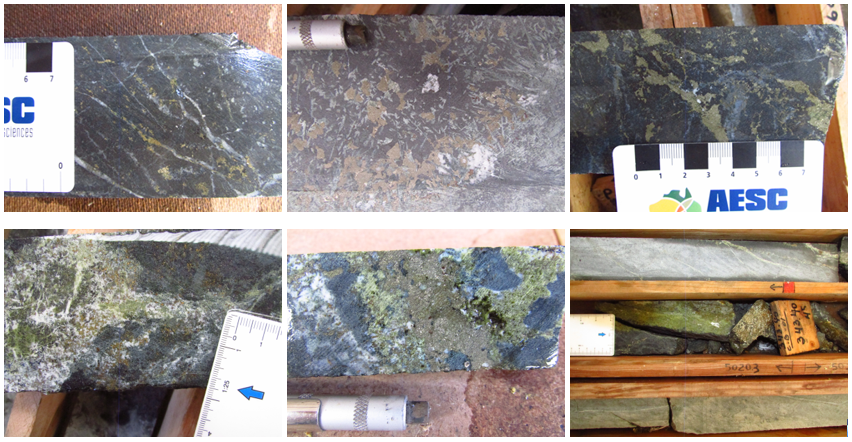
Figure 3: Examples of the copper-iron-gold mineralization intersected in drill hole CB-01. Photos a-c (Top row left to right) highlight the pervasive magnetite-pyrite alteration associated with Stage 1 mineralization, and photos d-f (Bottom row left to right) demonstrate the quartz-epidote-pyrite-chalcopyrite mineralization associated with Stage 2.
Gaby Prospect
The Gaby prospect hosts significant drill intersections to date from 29 holes (12 historic holes and 17 from Tribeca's two programs) for a total of 10,117m drilled. Combined with available geophysical datasets (IP and ground magnetic), these intersections indicate the presence of a large well-mineralized IOCG system intersected over 1.4km strike length at the Gaby target. The best copper intersections from drilling are as follows:
- 285m @ 0.40% Cu, 0.08 g/t Au, 269ppm Co and 23.5% Fe from 100m (LH-RC-07)
- 268m @ 0.66% Cu, 0.14 g/t Au, 330ppm Co and 24.7% Fe from 52m (GBY001)
- 94m @ 0.34% Cu, 0.07 g/t Au, 76 ppm Co and 14.8% Fe from 38m (GBY004)
- 186.7m @ 0.27% Cu, 0.05 g/t Au, 240 ppm Co and 18.0% Fe from 76m (GBY006)
- 264m @ 0.31% Cu, 0.06 g/t Au, 142 ppm Co and 14.4% Fe from 88m (GBY007)
- 224m @ 0.31% Cu, 0.06 g/t Au, 208 ppm Co and 21.4% Fe from 50m (GBY008)
- 172m @ 0.23% Cu, 0.05 g/t Au, 211 ppm Co and 15.2% Fe from 70m (GBY012)
Details of the historic drilling (LH-RC-series holes) are included in the NI 43-101 Technical Report dated October 24, 2022, with the GBY-series holes drilled by Tribeca are reported in the news releases of January 30, 2023, February 23, 2023, April 3, 2023, December 12, 2023, February 6, 2024, February 28, 2024 and March 27, 2024.
The outcrop at Gaby is dominated by aphanitic or porphyritic andesites (interpreted as equivalents to the Formacion Punta del Cobre – Belmar, 2010) and granite, granodiorite or diorite of the Complejo San Juan. These units are locally mylonitized or brecciated.
Alteration is variable, but commonly strong and dominated by albite-amphibole-magnetite±epidote, locally with pyrite and chalcopyrite, or oxide copper where weathered. The alteration may be pervasive (commonly the case with albite and or magnetite) or comprise veins and stockworks.
Ground magnetic and Induced Polarization (IP) surveying was completed by a previous owner at the Gaby target in 2004-2005, with lesser additional IP surveying completed in 2008. The line spacing of the 2004-2005 ground magnetic survey was 200m, with the IP survey lines spaced at 400m. The additional IP surveying in 2008 brought the IP line spacing down to 200m in the western portion of the grid. Tribeca completed additional IP surveying in 2023 to extend coverage further north at Gaby.
The geophysical data indicates the system is iron (magnetite) dominated with intense magnetic highs that invert to magnetic susceptibilities of significantly greater than 0.5 SI (>5-10% magnetite). The magnetic intensity is greatest in the south of the Gaby area, but while there is a general coincidence of copper mineralization and magnetite alteration there is not a direct correlation between magnetic intensity and copper grade.
G&T Metallurgical Services Ltd completed a metallurgical test work program in 2006. The program comprised optical mineralogy, grinding, flotation and magnetic separation test work, assaying, and reporting. The work indicated the mineralization intersected to date at Gaby is amenable to production of a copper concentrate and a high-grade magnetite product (66-70% Fe) through standard flotation and magnetic separation techniques, with further potential to produce a cobalt-rich pyrite concentrate.
Chirsposo Prospect
The Chirsposo prospect is located on outcropping rocks on a rise of approximately 100m topography in the central valley (Figure 5). The prospect was originally drilled by Latin American Copper in 2000, following mapping and trenching. Most holes were drilled on the outcropping strongly altered andesite and diorite, but one 200m step-out hole into the gravel-covered valley returned the best intersection of 82m @ 0.35% Cu, 19.2% Fe from 64m to EOH in hole CAB0006 under 25m of gravel (historic exploration activities are disclosed in the NI 43-101 Technical Report dated October 24, 2022).
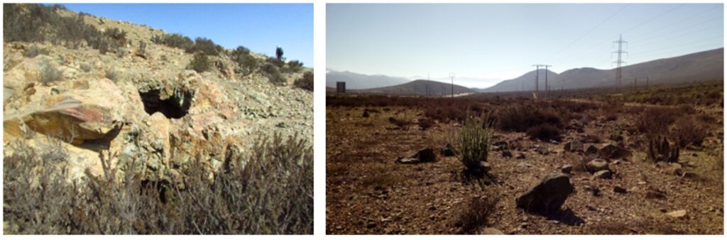
Figure 4: Photos from the Chirsposo prospect. a) Small copper oxide workings in outcrop near hole CB-01. b) View to the north along the central valley that hosts the Chirsposo project. The Ruta 5 highway and several powerlines traverse the valley.
Soil geochemical sampling (-80# fraction - aqua regia digestion - ICP-AES analysis - see the NI 43-101 Technical Report dated October 24, 2022 for details) has been undertaken over the Chirsposo zone where outcrop, sub-crop or residual soil is present. The zone is represented by a 1000m x 400m area of +200ppm copper in soil anomalism, peaking at 1200ppm copper at the eastern end where the gravel cover encroaches. The copper anomalism in soils is accompanied by anomalous Co-Fe-Mo-Ni-P-Va. No gold assays were undertaken on the soil samples but results from the diamond drilling of Peregrine suggest gold should also be anomalous.
The copper in soil anomaly is shown in Figure 5, along with the mineralized lens intersected by four drill holes with copper-iron-cobalt grade increasing and open to the northeast.
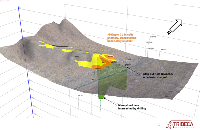
Figure 5: Location of the zones of +200ppm Cu (yellow) and +500ppm Cu (orange) soil anomalism at Chirsposo. The highest soil values are present as the outcrop disappears under thin gravel cover towards the northeast. Hole CAB0006 is a 200m step-out hole onto the gravel-covered valley and returned the best copper assay results (82m @ 0.35% copper, 19.2% Fe and 576ppm Co). The lens is open along strike from this intersection.
The extensive historical geophysical database includes IP survey data (24 line km) and ground magnetic data (120 line km) from surveying in 2007. The ground magnetic survey covered an approximate area of 4.0km x 4.0km, and delineated a series of large magnetic anomalies, with intensities up to 7000nT. The IP survey comprised 9 x 400m spaced 100m pole-dipole survey lines. Several targets comprising IP and/or magnetic anomalies were drilled by Peregrine in their series of five diamond holes, all of which intersected sulfide-bearing IOCG alteration, with varying levels of copper sulfide present.
Numerous coincident high chargeability-magnetic targets remain to be tested. Tribeca has planned a drill program to test for extensions to the Chirsposo zone, particularly where it disappears under gravel cover, as well as test additional targets elsewhere within the project area.
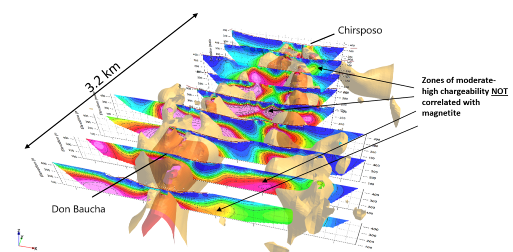
Figure 6: Summary geophysical data with 400m-spaced pole-dipole IP chargeability inversion sections (pink is >24 mV/V) and shells of the magnetic susceptibility inversion (red = 0.5 SI, beige = 0.25 SI). Numerous untested geophysical targets exist in the 3.2km area covered by the surveys.
Competent Person’s Statement
The information on this webpage is based on information reviewed by Dr. Paul Gow, Executive Director of Tribeca Resources. Dr. Gow is a Member of the Australasian Institute of Mining and Metallurgy (AusIMM) and the Australian Institute of Geoscientists (AIG), and has sufficient experience which is relevant to the style of mineralization and type of deposit under consideration and to the activity which he is undertaking to qualify as a Competent Person under the 2012 Edition of the Australasian Code for reporting of Exploration Results, Mineral Resources and Ore Reserves.